Provincia Britannia - Map & Guide (Nova Roma)
Home| Latíné | Deutsch | Español | Français | Italiano | Magyar | Português | Română | Русский | English
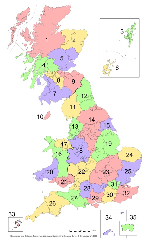
Britannia is divided into civitates. These are based on the tribal areas of pre-Roman Britain, which in turn formed administrative civitates in the Roman province.
For convenience, however, the modern civitates follow (with one exception) the boundaries of modern counties, unitary authorities, bailiwicks, and dependencies. Also for convenience Londinium and its environs, which in ancient times were in the territories of the Trinovantes and the Cantii, is now classed as a separate civitas.
Since the entire province is administered centrally by the governor and his assistants, the civitates currently serve no administrative function in the province. They are, however, a traditional and useful way to organize and classify places and events.
1 Caledonii
2 Taexali
3 Aemodae insulae
4 Damnonii
5 Venicones
6 Orcades insulae
7 Novantae
8 Selgovae
9 Votadini
10 Manavia insulae
11 Carvetii
12 Lopocares
13 Setantii
14 Brigantes
15 Parisi
16 Ordovices
17 Deceangli
18 Cornovii
19 Corieltauvi
20 Demetae
21 Silures
22 Dobunni
23 Catuvellauni
24 Iceni
25 Trinovantes
26 Dumnonii
27 Durotriges
28 Atrebates
29 Belgae
30 Regni
31 Londinium
32 Cantii
33 Casseterides insulae
34 Sarnia
35 Caesarea

